

Although the route of the Rayleigh Guard Trail Long March 2022 has not been officially announced, the main identification unit has announced the latest changes on Facebook and will be held on October 15th.
The main changes are as follows:
- Change the starting point back to the starting point, Tai Tam BBQ Area No. 2 BBQ
- The end point is changed to Shing Mun Reservoir
- The route is changed to mainly follow sections 1 - 6 of the Wilson Trail, with a total distance of 42 kilometers
Let's assume that except for the initial stage, we will follow the Weiwei letter route. We will analyze this. For the route and estimated arrangement, as for the final route information, please refer to the announcement of the conference.
In response to the above information, I believe that the conference is preparing for the physical competition, and the starting point will be changed to the barbecue area No. 2 of the Tai Tam BBQ Area, which can accommodate more participants. Except for the first section, it will be carried out according to the Weiyi signal path. The longest distance in the past. 156 kilometers or 78 kilometers, the longest is only about 42 kilometers, and the total climb is about 2128 meters. Since the overall difficulty is only moderate, the participants are more popular.
Since the conference has not announced the details of the subsections, we will first introduce the subsections of the Wilson Path.


Paragraphs 1-2


Paragraphs 3-6
<The route is subject to the announcement of the conference>
The first segment (distance: 6.65 kilometers: climb: 410 meters)
Since the starting point is changed back to the BBQ Area No. 2 of Tai Tam BBQ Area, after starting, you should turn right along Tai Tam Reservoir Road to near Tai Tam Tuk Reservoir Stone Bridge, then turn towards Tai Tam Middle Reservoir Huantang Ni Road to Zigang Bridge , pick up the Wei Yixin Trail, climb the Violet Mountain, and reach the end of the first section of the Wei Yixin Trail in Yangming Villa.
When training, you can take into account the supply of the supermarket in Yangmingshanzhuang.


The second leg (distance: 7.15 kilometers: climb: 375 meters)
The second section of the Wilson Trail will climb Jardine's Hill first and then Pony Hill. After going down the mountain, you will pass the Quarry Bay Jogging Trail and the Quarry Bay Tree Study Trail. There are many branch roads after going down, so you need to pay more attention to the instructions. After leaving Country Park, follow Keeley Road and King's Road to Quarry Bay MTR Station.
After the section on Hong Kong Island, after connecting to the Wilson Trail section, you have to climb Violet Hill, Jardine's Hill and Pony Hill. Climbing is medium, and most of them are off-road sections. With a lot of up and down, it can be regarded as a small performance test of skills. In addition, because it is still in the early stage of the competition, it is recommended to retain physical strength.
In addition, the tradition of taking the MTR will be retained, so participants need to find out in advance the fastest route from the entrance of Quarry Bay MTR station to the platform.
When training, consider replenishing at the convenience store in Quarry Bay.
Participants should make good use of waiting for the bus and taking a rest during the ride to help the body recover.


Section 3 (distance: 7.86 kilometers: climb: 471 meters)
After the participants arrive at Yau Tong Station, please pay attention to the traffic crossing the road, and then go straight along the ramp at the entrance of the Tseung Kwan O Chinese Permanent Cemetery, pay attention to the Wilson Path sign to cross the road, turn into the trail, follow the directions of the Wilson Path, and soon After reaching Zhaojinghuan Mountain, descend to Aojing Road. After crossing the road, take back the mountain trail and start to climb Wugui Mountain. After passing the highest point of Wugui Mountain, it begins to descend to Ma Yau Tong and Po Lam Road. Cross the road, take Tsui Lin Road and go up to Au Tau Village. After that, the road section turns into a trail. Follow the trail all the way to Clear Water Bay Road, cross the pedestrian path, and then reach Tseng Lanshu.
The whole section needs to climb several hills, but the climb is not much, and the more flat sections and slopes, the elite runners will run more and the speed will be higher.
Please pay more attention to the road signs as there are many roads and you need to cross the road and pass through the village.

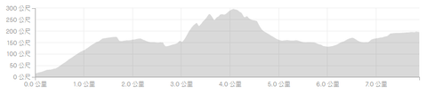
Fourth stage (distance: 7.70 km: climb: 572 meters)
This section is the most difficult section of the entire race, requiring more rugged sections and steep climbs.
Tsing Lan Tree has a store, which can be used for supplies, and can be taken to the urban area by bus or minibus.
After starting from Tseng Lanshu and crossing the village, you will enter the Saigon Ancient Road with rough road conditions. The section along the ancient road is not too long. Soon you will reach the Da Lan Lake aqueduct. Go along the aqueduct, turn left according to the sign, and start to climb. Going up Dongyang Mountain, this is the largest section of the entire race. After that, the road climbs all the way. After reaching the highest point of the climbing section, it will pass a short section of relatively flat mountain trail before reaching Fei Ngo Shan Road. Along Fei Ngo Shan Road, it will connect to Sha Tin Col Road and arrive at Sha Tin Col.


Section 5 (distance: 8.23 kilometers: climb: 29 meters)
There are stores in Shatin Col, which can be used for replenishment and rest. The later section is not difficult, runners can challenge the speed as much as possible. First detour to the public toilet after the store, walk for a short distance along the concrete road, and follow the signs to turn in Dirt road, go all the way down the mountain, you will reach the aqueduct. After about 7 kilometers of the aqueduct, you will reach Tai Po Road, the end point of this section.


Section 6 (distance: 4.94 kilometers: climb: 275 meters)
Crossing Tai Po Road, you will pass Kowloon Reservoir and Shing Mun Reservoir. Follow the signs to go there, climb slightly, and then turn flat. This section is mostly covered by big trees, and there are many horses. The latter section rises slightly, and soon After reaching Jinshan Road, walk along the concrete road for a short distance, then turn back to the dirt road and go down the mountain, and you will reach the Shing Mun Reservoir.
This section of the road is mainly a small up and down, but there are many forks, so you should pay more attention to the instructions.

