
![HK100 2023 路線攻略 (1) [THE THIRD (33Km)]](http://cam2.com.hk/cdn/shop/articles/tattoo-the-third-orange-1.png?v=1676351649&width=1600)
The Vibram Hong Kong 100 Ultra Trail Race, the first 100km trail race in Hong Kong after the epidemic, will be held during February 16-19, 2023. This year's competition is divided into three groups: THE THIRD (33Km), THE HALF (56Km), and HK100 (103Km). We will analyze each distance group one by one.
With the development of the epidemic, most of the anti-epidemic measures have been withdrawn, so support and dietary arrangements have become easier to handle, but there are still many places that need attention.
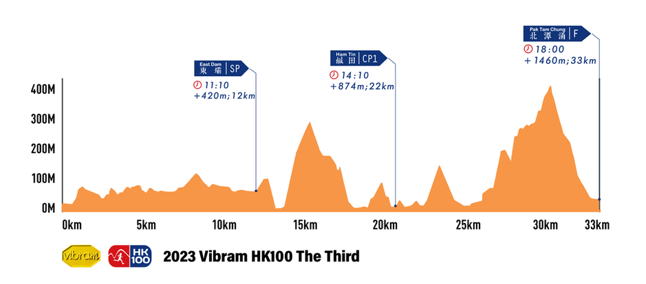
THE THIRD (33Km) is an added distance group this year and will start at 8:00 am on February 16th. The total length of the race is 32.66 kilometers, with a total climb of 1418 meters. The starting point and finishing point are located in Pak Tam Chung. There are a Service Point (SP) and a Check Point (CP). The overall difficulty of THE THIRD (33Km) is moderate. For entry-level runners, as long as they have enough training, they should be able to complete it.

(Image source: Vibram Hong Kong 100 Ultra Trail Race )
Pak Tam Chung (starting point) - Dongba (SP) distance: 12 kilometers, climb: 420 meters
Starting from the starting point at Pak Tam Chung, walk along the concrete roads of Tai Mong Tsai Road and Man Yee Road for about 800 meters, then turn right to Shang Yiu Country Trail, which is a section of about 5 kilometers, with a small range of ups and downs The road section will return to Wanyi Road, and then along the concrete road, after about 5 kilometers, it will reach Dongba. The overall ups and downs of this section are not large, and participants can run at a relatively easy speed.
East Dam (SP) - Ham Tin (CP1) Distance: 10km, Ascent: 454m
After passing through Dongba (SP), enter the section of the trail, first climb a little, then descend to Langjiawan, and then climb to the first mountain on the route, which has a relatively large rise, and descend from Saiwan Mountain. Arrive at Sai Wan, then follow the trail to Ham Tin (CP1). Since there is a relatively large climbing section at the beginning of this section, more attention should be paid to the use of physical strength.
Ham Tin (CP1) - Pak Tam Chung (Finish) Distance: 11km, Ascent: 586m
After leaving Ham Tin (CP1), walk across the path to Tai Wan Beach, then take the path behind the beach to Tai Long Village to connect to MacLehose Trail, turn left at Chek Keng and go up the hill. After a certain climb, you will arrive at Luhu Country Trail , turn right to Luhu Country Trail, after a short section of relatively flat road, then board the highest point of the route, the big pillow cover, then start down the mountain, return to Tai Wang Tsai Road, and finally return to Pak Tam Chung along the concrete road about 1.8 kilometers The end point, this section is a section with more climbs, and it is already the end of the race, so it is necessary to reserve enough physical strength to cope.